Forest Inventory
The forest inventory was performed to gather data about the pilot sites but also to pioneer a Participatory Carbon Stock Assessment (PCSA) methodology in Vietnam. This methodology integrates the local people in the process from the very inception of the project. This section explains the PCAS process. For a sense of what it is like in the forests take a look at the photos page.
Background
While satellite images can provide sufficient data to define deforestation rates, the analysis of degradation dynamics still needs ground-truthing. Local people / local forest owners can provide the data or independent consultant bodies are assigned to assess the forest. The government of Vietnam tends to use consultants since only one percent of forest areas are currently under community management. In order to protect a forest sustainable it is important to integrate local people in any forest management and enhance the commitment of local people. Integrating local people in basic forest inventory measures is an effective way to achieve this. Furthermore, assigning local people to monitor forest areas is by far the cheapest solution and can cover large areas. This is not a new concept in Vietnam since forest protection has been a key part of any major (national) forest program. Usually financial compensation is provided for involving local people in forest protection schemes. It might be feasible to integrate local people and knowledge into new established forest consultancies to monitor state-owned forest areas more properly.
Experience from several forest projects in Vietnam show that without the participation of local people forest protection is impossible. GTZ in Vietnam promote the integration of local people from the start in any REDD related activity.
Even if the methodology of PCSA is well known it has not been piloted in Vietnam. Dak Nong province was a good site for the pilot since it has been identified as a potential REDD area and the Tay Nguyen University has already carried out scientific work on carbon contents in the area. Based on numerous field measurements the University elaborated a mathematic regression, which allows the conversion of measured forest inventory data into carbon values.
PCAS Guideline
A detailed PCSA guideline was prepared by Prof. Bao Huy lecturing at the Tay Nguyen University in Buon Ma Thout, which was commented by the GTZ EPMNR project. In general, the guideline encompasses the following steps:
- Discussion on the forest status and management goals of every forest block together with the forest owners / community
- Identification of coordinates, where the sample plots are measured. Print out of a satellite image was prepared in advance and participants just identified the coordinate of the sample plots (a grid was drawn on the map and farmers metering the X and Y coordinates (grid net distance was defined as 225x225m displaying a sample plot intensity of 1% of the forest area).
- Field work
- Participatory summarization of collected data and discussion on outcomes
- Participatory carbon calculation (carbon contents per diameter class are provided by the Tay Nguyen University)
- Practical implementation of the field work and results
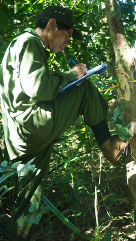
PCSA in Practice
After two days practical training the field work was conducted. There were no difficulties other than the steep learning curve needed to master the use of the GPS in the field. The inventory teams consisted of three to four farmers and one technician. At least two group members could write and the others measured the tress. At least one farmer of each group possesses sufficient knowledge to identify tree species.
56 sample plots in Village 6, 108 in Village 5 and 134 in Village 4 were measured. Each sample plot has an area of 500 m2. The total investigated area comprises about 1,500 ha (1% of the total forest area). Approximately, 150 different tree species were recorded, which underlines the high biodiversity value of these forests. Tree names were recorded in M’Nong as well as in Vietnamese language but systematic classification by scientific names was not done and needs the support of botanical specialist. But it can be stated that the biodiversity value of such forests is high, which underlines the importance of protecting them. All tally sheets have been stored and the data were digitalized. Data collection was finished by the end of January and data sorting and interpretation by end of February. So far the project was not able to conduct a wrap-up meeting (discussion of the forest inventory results and participatory carbon calculations) with the villagers but the plan is that the GTZ EPMNR project will present and discuss the outputs by end of May with the villagers.